Leaving Park City I was faced with 3 ½ weeks of solo travel before Jan would get back from China. We had agreed to meet in Sacramento which meant I had quite a bit of time in Nevada to go exploring. I’m going to try to get all of Nevada into one blog, probably not a fair thing to do to the fathers of Nevada, but the reward is that I get closer to real time in blogging. For those of you who bear with me, I’ll put in several recipes along the way to make reading this blog a little more “appetizing”.

Wendover Nevada was my first stop. Years ago when we still lived in Utah, we would every once in a while head over to Wendover, past the Great Salt Lake, where one foot into the state delivered you a full fledged casino.

I think there were only a couple of them back then, small one level casinos but jammed to the rafters with people from Utah all gambling. Today, there are four major casinos, huge entities and just as many people. The town has grown quite a bit due to the casinos and it sports quite a few interesting things to do.

Wendover Will, billed as the world’s tallest mechanical cowboy, was created in 1952 when it was erected at the state line at a service station that eventually grew into the State Line Hotel & Casino, which in turn became the Wendover Nugget. Donated to the city in 2004, the mechanical cowboy was moved to the center of town as a symbol of its continuing development and to welcome all to “This is The Place where the West Begins”. Pretty heady stuff.


At the entrance to the Montego Bay Casino & Resort lies The Transcontinental Telephone Monument. It’s story is actually pretty cool in that on June 17, 1914, the last pole of some 130,000 was erected there and with that final splice it introduced the east and west coasts of our country to voice communication. Participants in that first call: Alexander Graham Bell, inventor of the telephone and co-founder of AT&T, speaking from New York. Thomas Watson spoke from San Francisco, AT&T President Theodore Vail spoke from Jekyll Island in Georgia, and U.S. President Woodrow Wilson spoke from the White House.


There is a vantage point just outside of town where one can see the actual curvature of the earth as I-80 stretches from Wendover towards Salt Lake City and across the Bonneville Flats and the Great Salt Lake. “The Earth has a radius of approximately 3965 miles. Using the Pythagorean theorem, that calculates to an average curvature of 7.98 inches per mile or approximately 8 inches per mile.” Sounds easy enough, but in reality there are few places where this curvature is noticeable as even airline pilots have a hard time seeing it when flying under 50,000’.


For years the Bonneville Salt Flats were home to annual speed racing events, both solo and head-to-head. Due to a lack of a firm crust necessary for running any and all types of racing vehicles the annual event was canceled the past several years. But because of a wet spring there was enough moisture in the bed to create that much needed crust and the race was on for August of this year.
I guess I’ll throw in a bunch of appetizer recipes for the readers to fix as they motor on through this blog. Rob’s grandmother didn’t cook much, never had to, but she did make a couple of things I loved – ceviche and empanadas. Unfortunately her recipes went with her, but this one from the July 2010 issue of Cooking Light is as close as I can remember. Enjoy!
Elko, situated on the Humboldt River and located halfway between Reno and Salt Lake City, is a sort of melting pot of different ethnicities that were brought together by the allure of gold, cattle and the railroad. The Native American Shoshone Indians who originally settled the land hundreds and hundreds of years before the first settlers arrived eventually mingled with the Basques, Hispanics, Chinese and European settlers that were drawn to the region. Today, there are celebrations throughout the year that bring to life the many different heritages that can be found in Elko.


One stop very worthwhile making is at the California Interpretive Center, located about 8 miles west of town. Here one can trace the expansion westward of this country in the mid 1800’s by farmers, miners, ranchers, saloon keepers all drawn by the promise of nice weather and wide open spaces and a better life than the economic depression that was pandemic in the Eastern half of America. There were four trails that these settlers could follow, all starting in St. Louis, Kansas City, and Independence Missouri, rough treks through unchartered territory fraught with the danger from Indians and weather.

The Oregon Trail took life when 69 settlers started out from Independence, with California being the ultimate destination, and went as far as Soda Springs Idaho where they split the party into two. The one group hired guides to help them navigate the waters of the Snake River, over the Blue Mountains, and then hired Indians to guide them down the Columbia River and into the Willamette Valley, a trail that was blazed some 40 years earlier by the expedition of Lewis and Clark.


The other 39 settlers “knowing only that California lay to the west” struggled across the Great Salt Lake Basin and made it to the Humboldt River in what is now Nevada from where they proceeded to California. Later expeditions took other routes that eventually got them to different points in California, and today’s California Trail is a map of many trails all heading west.


With the Oregon and California Trails pretty well established, one of the great migrations in the history of this country started in Nauvoo Illinois and became known as The Mormon Pioneer Experience. The Mormon Church, begun in 1830, was vastly different from other established religions in its beliefs and tenants, and in order to escape mounting harassment, antagonism and persecution, Brigham Young, the successor to Joseph Smith, the founder, organized the first migration to the great valley of Utah. Using the maps of the Oregon and California Trails, the first groups improvised slightly on the trails and eventually reached the promised land thereby creating the Mormon Pioneer Trail which would serve as the guide to the many subsequent emigrations. It was a very difficult journey, many died along the way, but the mission itself established a community where for some time the Mormons lived with their own set of beliefs away from the damning eyes of non-believers.
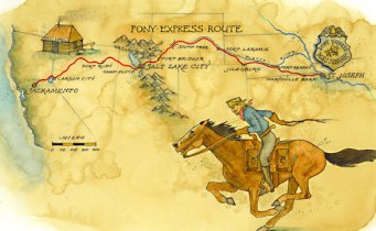
As the West was settled by those first settlers and thousands of subsequent expeditions, there arose a need to have better communication between the East and the West. The use of ships to carry mail through the Panama Canal proved costly and ineffective. The use of stagecoaches via the southern territories such as Arizona became political hot buttons with the approaching Civil War, and so the Pony Express Trail was born. The concept was genius for the time – a series of way stations, rest stops and overnight accommodations that would enable a piece of mail to travel from one coast to the other in 8 days. There were five elements to the trail, the first starting in St. Joseph, MO going to Kearney Nebraska, from there to Fort Laramie in Wyoming, following the Oregon and California Trails, then using the emigrant trail to the Salt Lake Valley which led to the fourth part of the trek which crossed the Great Basin of Utah and eastern Nevada. The final leg would be the hardest, crossing the western Nevada desert and going over the Sierras into Sacramento and San Francisco.
Enduring stories about those men, their horses and the way stations that were created are a part of our American heritage to this day. However, the venture was fraught with underfunding and it was never awarded a contract by the US government. It managed to survive as a private enterprise for only 19 months before folding but the now romantic legacy of the Pony Express is celebrated to this day.


There were a couple of other day trips I took out of Elko. One was to the town of Lamoille and the glacier carved canyon that it sits at the base of. The Ruby Mountains soar over the town which has several quaint eateries and B&B’s and The Little Church of the Crossroads, the most photographed church in Nevada and the site of some 600 weddings throughout its history.

West on I-80 you come to the town of Carlin, which in the 1800’s was a resting stop for emigrants heading to California. Located on the banks of the Humboldt River, Carlin today is kind of run down and easy to skip. But not far away is the ghost town of Palisade, my first foray into the deserted towns of the west.


A 1927 Model T for sale $8500, on the way to Tuscarora.

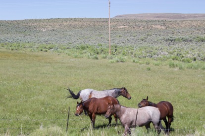
Not sure if these were wild or merely out grazing for the day, but they were a pretty sight just standing there.
The ghost town of Tuscarora lies to the north of I-80, an old gold mining town that lost its identity and soul when the placer deposits ran out. The drive out there made for some interesting photographs.


I got into bacon appetizers for a while until I realized that it was becoming a worse habit than my 8º vodka. I saw this recipe in the “grandparents.com” blog who had reproduced it from a book called “MY PERFECT PANTRY” by Geoffrey Zakarian. Oh this good!
brown-sugar-and-black-pepper-bacon
Next to last stop was Winnemucca. Now, usually there have been a few things to do in and around small towns where we have stopped – Deming, Truth or Consequences, Delta – but I’ll be honest there wasn’t a hell of a lot to do around Winnemucca. One of the attractions listed was a visit to the local brothel, a legal one and while the thought intrigued me in that I would have a hard time figuring out what lens to use on my camera, discretion overtook the better part of valor. As in every town and city in Nevada there were a couple of casinos, smoky, ill-lit, seedy, and run-down but replete with characters you would expect to find in these places.

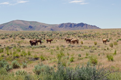
One of the guide books says that Winnemucca is a base camp to the great outdoors. Opal mines, rock hounding, off-roading, and fishing all are available within short distances. One nice drive I took was to the Water Canyon Recreational Area, an area managed by the local BLM field office and replete with flora and many species of animals. I also saw another herd of horses although I’m pretty sure these were tame; a pretty sight nevertheless.


There are numerous ghost towns nearby, totally understandable given the location and they were interesting to see. Hinkey Summit was a possibility to explore, located some 40 miles out of town and just past the town of Paradise Valley, but the access road quickly turned to gravel and washboard so I scrapped that one.


One redeeming aspect of Winnemucca and the outlying areas is that it is visually a pretty area, with the mountains surrounding small valleys and lakes and reservoirs.

When we were in Chile last year Josh and Vivi showed us how many varieties of empanadas there were in Chile and all of South America. Rob’s grandmother, Lalita, made them too, and well, and they were always on my wish list whenever she got the urge to make them. This recipe calls for beef, but as you can see from the jingle, there is no end to what you can put in them.Have fun!

The appropriately named Sparks was my last stop in Nevada and I stayed at the Sparks Marina and RV Resort, which actually was not on a lake or marina but perhaps ½ mile away from water of any sort. No matter – the resort was great – modern, clean and for the fourth of July relatively quiet. A chance to clean up the coach!

This layover kind of felt like a stopping place the old settlers might have visited to re-provision their supplies. I was about out of booze, wine and food and clean clothes so I took advantage of the local COSTCO, Total Wines and laundromat. I picked up some forwarded mail and replaced my Direct TV receiver which had fried in the desert of Nevada. I also spent a great day with Jake’s in-laws who had just moved to Reno and built a gorgeous home overlooking the mountains and the city. Stan and Lynette invited me out for the day to watch a pro golf event and dinner. Super day with super people.


My last mission in the area was to check out our next stop, an RV park in Pollock Pines high in the Sierras. No easy way to get there for the faint of heart and after a few Freudian slip wrong turns I managed to get to the summit and the town. The resort was a real disappointment so I cancelled that stop in my head and drove back to Sparks along Route 50 and through the town of South Lake Tahoe, major mistakes cuz’ it WAS the Fourth of July weekend. And this. Major queezies.

And it was off to Northern California.
So if you made it this far here’s the last appetizer recipe. I made these for the last Super Bowl part we had and they were gone in the blink of an eye. I can’t remember the source for this recipe, but if you make it, make a double batch, or a triple batch, or a quad – it’s that good and too easy. Happy crunching!

Leave a comment